Monster storm bears down on California
Los Angeles, 5 February 2024 (tca/dpa/MIA) - California girded Sunday for a "potentially historic" storm that put much of the state on high alert, with officials expecting life-threatening damage and issuing evacuation orders or warnings in parts of Los Angeles, Ventura, Santa Barbara and Monterey counties.
"This storm is predicted to be one of the largest and most significant in our county's history, and our goal is to get through it without any fatalities or any serious injuries," Santa Barbara County Sheriff Bill Brown said at a briefing Saturday.
This storm could surpass the effects of a powerful storm that hit January 9, 2023, said David Neels, the Montecito fire chief. That event forced the mass evacuation of Montecito, flooded Santa Barbara and left US Route 101 covered with mud, forcing its closure. It caused more than $80 million in damage to Santa Barbara County, Brown said.
"Our slopes are saturated once again," Neels said, adding that geologists are warning about the potential for landslides from this storm. "The likelihood of sediment mobilization is real."
Brown said 6 to 12 inches of rain is expected for Santa Barbara County's mountains. "But more concerning is the projected duration and sustained amount of rain that we can expect this weekend," he said.
"Unlike the rain that caused (last year's January 9) debris flow, for example, the intensity of this storm's rain is not expected to exceed an inch or an inch and a quarter per hour. It's just that the rainfall will be far more sustained, over a more or less continuous period for 24 hours or more," Brown said. "We're anticipating the possibility of flooding of streets and neighborhoods and of our highways and freeways."
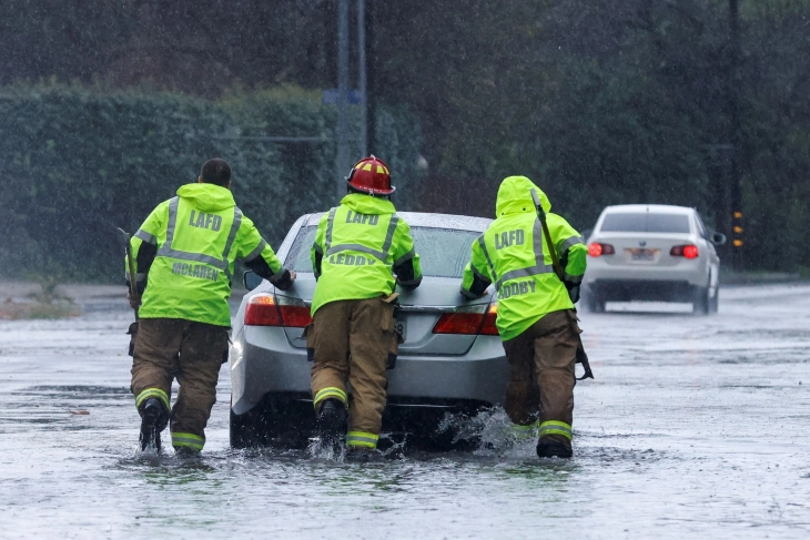
Los Angeles issued an evacuation warning for about 50 homes and businesses along a section of La Tuna Canyon Road in Sun Valley on Saturday just before midnight, around where McDonald Creek drains into La Tuna Canyon. The county Department of Public Works warned that heavy rain would bring significant flooding and mudflows to the area.
The National Weather Service said there was a "high risk for flash flooding," a designation used only a few times a year anywhere nationwide, meteorologist Ariel Cohen said at the briefing.
"About half of flood-related deaths occur in high-risk areas. This includes all of the Santa Barbara area, all the way to Los Angeles. This is a particularly dangerous situation," Cohen said. "I can't stress enough the importance that everyone be at a very high state of readiness. Take those precautions to save your life from the upcoming floodwaters that will affect the Santa Barbara area."
The National Weather Service issued an extraordinarily rare "hurricane force wind warning" overnight just off the Central California coast, stretching from the Monterey Peninsula, past Big Sur, to the northern edge of San Luis Obispo County. There hasn't been a hurricane force wind warning issued off the California coast for at least decades, the weather service said.
A tornado or two are possible in the San Francisco Bay Area, as well as in Santa Cruz, Monterey and San Benito counties.
The storm was hitting the San Francisco Bay Area and the Central Valley earlier Sunday, but the most significant rainfall totals are expected in Southern California and on the Central Coast, National Weather Service meteorologist Eric Schoening said at a separate briefing Saturday.
Los Angeles County, as well as Ventura, Santa Barbara and San Luis Obispo counties, were designated as having the highest weather risk level — extreme, colored in purple, the worst on a five-level scale. Forecasters said there was a 40% to 70% chance of life-threatening and damaging flooding in those areas.
Heavy snowfall is expected for the mountains, Schoening said, and gusts are expected to down trees and power lines.
"These next storms are going to be impactful and dangerous, and most of the damaging impacts most likely to our coastal and southern regions in the state," said Nancy Ward, director of the California Governor's Office of Emergency Services, at the briefing. Storms are "the most dangerous natural disasters that we have — killing more people ... than wildfires every year."
Ward urged that people avoid nonessential travel during the storm's peak.
"Don't walk, swim or drive through flooded waters," Ward said. "Six inches of water can down an adult in that water. Twelve inches of water can sweep away your vehicle."
Five rivers in California are anticipated to hit the flood stage: the Ventura River in Ventura County, the San Diego River in San Diego County, the Guadalupe River in Santa Clara County, the Carmel River in Monterey County and the Russian River in Mendocino County, said Karla Nemeth, director of the California Department of Water Resources.
There are also 16 river systems that could hit flood monitor stage. In the Central Valley, reservoirs were already starting to drain stored water downstream to make way for incoming floodwaters, Nemeth said.
The powerful storm is arriving through an atmospheric river, a long plume of water vapor that pours into California from the Pacific Ocean. It carries so much water that it's likened to a river in the sky.


